Thursday, April 30, 2009

Maria crosses a new milestone

I'd been monitoring closely Maria's odometer, as she approached today's milestone.

We both crossed it together while enroute home from Denver International Airport where I'd spent the day in meetings with customers and UAL employees/contractors.

What's the milestone you ask? Well, today Maria crossed over the 66,666 mile mark on her odometer. No "mark of the beast" commentary is warranted, thank you very much, Maria remains a "good girl" for me.

There were no whispering voices in my helmet, just the sound of the wind making its way across the windswept plains.

The sun was not suddenly eclipsed by the moon and neither did dark and forbidding clouds streaked by lightning bolts make their appearance.

The ground did not open before me with flames licking out from the underworld.

Maria remained as compliant to my bidding as usual and did not try and kill me while possessed by the "dark one". No cagers tried to kill me or even seem threatening.

I looked for and found no evidence of blood flowing from Maria's bodywork. All in all, a pretty benign crossing of this particular milestone.

The sun remained shining, the winds weren't blowing too hard and temperatures were in the mid-50s or so as I stopped on the side of the E-470 superslab to take the picture below.

Sunday, April 26, 2009

Riding the Stove Prairie Road to the Cache La Poudre Road

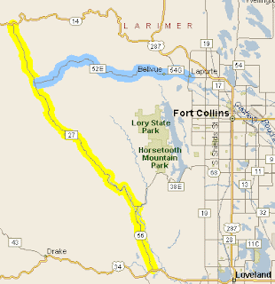
The weather today was much nicer than yesterday's weather. The forecasters said we'd get a high of 60F° and sunny. Heck it was 50F° when I left the house around 09:15 AM and it felt very nice. Today's ride was one I'd been wanting to do for quite a while now, ever since I read about it on Ken Bingenheimer's blog: Passes and Canyons: LINK

Courtesy: Passes and Canyons Blog

I took the I-225/I-25 slabs out of SE Denver metro and headed north to the junction with US 36. I took US36 to where it junctions with US287 which heads north through the towns of Broomfield, Lafayette, Longmont, Berthoud and finally Loveland.

US34 is also known as the Eisenhower Parkway at this point. It's a nice leisurely road taking one out of Loveland after a few minutes of riding. Of course, I missed the turnoff northwards to the Stove Prairie road since I was looking for CR56 but its really CR27, aka Buckhorn Road!

No problem though, I went on US34 through the Big Thompson Canyon and it's wonderfully twisting roads and high rocky canyon roads. I got all the way to Drake, checked my printout of the map above and turned around. Here's some photos I took of some of the spots along the Big Thompson Canyon road where I could safely pose Brigitta, my 1987 R80 Beemer.


I soon arrived at CR27 where I'd spotted some nice looking rocky mesas while westbound on US34. Here's what the road looks like near where I turned off US34 to start going northwards on Stove Prairie Road/Buckhorn Road.

The view north shortly after turning off of US34 on CR27, though I dimly remember seeing a CR29 sign as well. Just look for the above mesa and you'll be fine.

The first half of the road was pretty benign in terms of curves and twisty turns, just really gentle curves and farmland for the most part. You're climbing gently the whole time and the occasional patches of loose gravel on the curves kept my speed down.

Now, having said that, the second half of the Stove Prairie Rd turns very twisty with lots of blind turns and rocky walls on one side with dropoffs on the other side. I got high enough in altitude to see small pockets of snow laying by the side of the road! The temperature did not get below 46 degrees though and the sun kept things warm enough.

It's a the small town of Masonville where one has a choice of going east on CR38E towards Horsetooth reservoir or west on CR27 towards CO14. I took a small break to get the following pictures:


A closeup of the coffin's wording

Brigitta, with what I imagined to be wild horses bolting from the gates of hell
(a bit of poetic license is requested here)

I headed west towards CO14 which I reached about 19 miles later, 19 very twisty miles I might add. Very enjoyable even at the slow pace I was going due to the gravel I found once in a while.

I paused when I got to CO14 to eat the lunch my loving wife had made for me and rest for about 15 minutes. It was not exactly warm but it was not that cold either. I enjoyed listening to the sound of water flowing back on the Cache La Poudre river and watching the lone fly fisherman trying his luck.

The junction of CR27 and CO14, my lunch site

After lunch, I geared up once again and headed east on CO14, I didn't realize I was very close to a tunnel I knew was on this road and was almost surprised when I came upon it within a few minutes. Here's a few shots of the tunnel with Brigitta, hope you like them:


I continued eastward on CO14, enjoying the twists and turns through the canyon carved out by the Cache La Poudre river. Cache La Poudre, by the way, is French for "Hiding place of the Powder". It's a designated Colorado Scenic Byway and a popular riding destination for motorcyclist and other sports lovers.

Wikipedia: It refers to an incident in the 1820s when French trappers, caught by a snowstorm, were forced to bury part of their gunpowder along the banks of the river. Full Article here: LINK

I was a bit worried about running out of gas at this point as I was not sure how close I was to Fort Collins from the above tunnel. Yep, I'd forgotten to bring along with Kolpin gas can dammit. My odometer told me I had perhaps 30 miles range left at this point. However, I had not had to go to reserve when I spotted my first gas station where CO14 meets with US287. So I continued onwards to Fort Collins, stopping just past the city limits at a Shell station when my odometer read 186 miles traveled. Imagine my surprise when I went to fill up and the tank only took a bit over 3.5 gallons! I estimate I was getting 55 miles to the gallon on this ride!

The rest of the ride was boring riding on US287, passing through the same towns that I cruised through on the way up. Sure, lots of traffic lights at times but there were also stretches of highway where one could build up some speed as well. Much better riding than what I believe was the congested slab known as I-25!

I arrived in the Denver Metro area and used US36 to I-270 to I-225 in that order in steadily building traffic. I got rained on briefly as the metro area was overcast and in the mid-40s. No big deal and things dried out by the time I took the Parker Road exit.

I was home by 4:00 PM or so, about six hours of saddle time and 260 miles racked up for the ride. The weather sure was better north of the metro area, but it still wasn't too bad overall. Hope you liked the pictures and that you got some riding in today as well!

Saturday, April 25, 2009

Downtown Denver Lower District: Then and Now

In order to make up for the low moral values exhibited in my previous posting, today I offer you views of buildings in Denver's Downtown Lower District's historical area. The original plan of the day had been to ride up towards Loveland and the Horsetooth Reservoir area but the weather did not cooperate.

I rode out of the house a bit before 08:30AM and it was heavily overcast and misting. Couple that with temperatures in the high 30s to low 40s and my enthusiasm for being on the road in those conditions diminished rapidly.

Instead, I diverted over to the Denver downtown area, exiting the I-25 slab at the Speer Boulevard South exit. My initial stop was going to be Union Station for pictures. It had been in the news recently when it was announced the nation's last ski train was ceasing business and closing its doors. It's last ride to Winter Park was 29Mar09.

On the way to Union Station, on Wynkoop Road, I spotted this great looking brownstone brick building with faded paint advertising the O'Fallon Supply Company:


The O'Fallon Supply Company, founded by Martin J. O'Fallon. An Irish immigrant who started off as a $2.50 Janitor, eight years later becoming the president/owner of the O'Fallon Plumbing Supply Company.
O'Fallon Bld, Circa 1900
DPL Call#X-22445

The O'Fallon Building above was the only one I could match up to a historical photo from the Denver Public Library. There were several other buildings built along the same architectural lines and it leads me to believe this area probably started as "warehouse row" since it was so close to Union Station.


Denver's Union Station, Circa 1914
 DPL Call #MCC-2394

Wikipedia: The original structure, Union Depot, was built in 1881 and later destroyed by fire in 1894. The second station was rebuilt in Beaux-Arts style. Each of the first two structures included clock towers. In 1914 the station's central building was demolished and rebuilt to keep up with increase traffic at the time. During its heyday, it was served by 80 daily trains operated by six different railroads. Full Article: LINK

Over at the Southern end of Wynkoop, the street deadends onto one of the last remaining iron bridges over the Platte River which flows through the heart of Denver:

That's the Pepsi Sports Center in the background


Looking back towards Union Station from the above bridge
Kind of looks like a warehouse row doesn't it?

I wandered a ways from Union Station and found myself in the parking lot of the Pepsi Sports Center. While the pictures of this sporting center did not turn out as I'd wished, the one of what used to be the Denver Dry Goods building worked out:


Denver Dry Goods, Circa 1933
DPL Call# X-24064

Wikipedia: The Denver Dry Goods Company, also known as "The Denver", was established in Denver, Colorado in 1879 by Michael. J. McNamara and L.H. Flanders as M.J. McNamara & Company and later The McNamara Dry Goods Company. Full Article: LINK

From the above location, I could see the chimney stack and tower of the Tivoli-Union Brewery located in what's now the Auraria College Campus. It remains quite the building as you can see:


Tivoli Brewery, Circa 1890, link to DPL Call# c-196
Circa 1938, link to DPL Call# chs.x9229

Wikipedia: The Tivoli Brewery is a historic landmark in the Auraria Neighborhood of Denver, Colorado. It is the former home of the Tivoli Brewing Company, which took its name from the town of Tivoli in central Italy. Today, the building is home to the Tivoli Student Union of the Auraria Campus, serving as a student center for the Metropolitan State College of Denver, the University of Colorado Denver, and the Community College of Denver. Full Article: LINK

And now, for something completely different, as they say in Monty Python's Flying Circus show. Wouldn't want you to think I am totally indifferent to more modern "art".

Near the Denver Performance Arts Center

OK, enough of that!

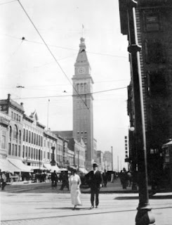
Next up was the Daniels & Fisher tower, a Denver landmark since it was built in 1910 as part of the Daniels & Fisher Department Stores. It was modeled after the Campanile Tower in Saint Mark's Square in Venice, Italy. More info here: LINK


Daniels and Fisher Tower, Circa 1910
DPL Call# x-23066

I next wandered across the I-25 slab towards the Zuni Street area and found some more aged structures that I wanted to photograph:
Asbury Methodist-Episcopal Church
Circa 1900-1920,  DPL Call# x-25610

Here's a shot of the metal archwork bridge spanning the Platte River and on which Speer Boulevard rides.

Speer Boulevard Bridge over the Platte River
Built by Central Denver Ironworks

Nearby is this metal archway strung over a pedestrian overpass allowing folks to cross over the I-25 slab.

Wandering about still, I saw what looked like a nice old church in the distance. Its located near Denver's North High School building complex:

Saint Dominic's!
Saint Dominic's Church, circa 1984
link to DPL Call# x-25399

Coming down from Saint Dominics, my eyes were drawn to what looked like to be a giant milk container, the old fashioned kind one sees in dairy farms. Quite the cute motif for what turned out to be an ice cream stand. Here's the "Little Man Ice Cream" shop:

The Little Man Ice Cream Shop

At this point, I got on the I-25 Slab southbound intending to get home for lunch. Brigitta went into reserve tank as I rode along so I exited on the Washington Street exit. This placed me within sight of a tall tower/steeple I'd seen before while on the slab. It's apparently covered in gold leaf, or what looks like gold leaf, just like the state capitol building. Turns out its the Williams tower, part of the Ritchie Sports Center of the University of Denver.

Williams Tower at University of Denver

I tanked up nearby on Evans and as long as I was there, wandered about the university campus looking for its original buildings. The first one I found was at Observatory Park and coincidentally enough, it was the Chamberlin Observatory which apparently has been there since the late 1890s.


Chamberlin Observatory, Circa 1890
link to DPL Call# whj-1027

Wikipedia: Chamberlin Observatory is an astronomical observatory owned and operated by University of Denver. It is located in Observatory Park. It is named for Humphrey B. Chamberlin, a Denver real estate magnate who pledged $50,000 in 1888 to build and equip the facility. Full Article: LINK

Next up were the university's oldest buildings, the first being the Mary Reed Library building which is now the school's administration building I believe.


Mary Reed Library,Built in 1932 per Wikipedia, circa 1920
link to DPL Call# chs.x5186

Wikipedia: The University was founded in 1864 as Colorado Seminary by John Evans, the former Governor of the Colorado Territory, who had been appointed by President Abraham Lincoln. The 'Colorado Seminary' was founded as a Methodist institution, and struggled in the very early years of its existence. By 1880, the Colorado Seminary had been renamed the University of Denver. Full article: LINK

Next to the Mary Reed Building is the Iliff School of Theology, quite impressive as you can see:


 Iliff School of Theology, Circa 1892
link to DPL Call# c-183

Wikipedia: Iliff was originally founded in 1889 by as a seminary and school of religious studies of the University of Denver. In 1892, it was named the Iliff School of Theology after John Wesley Iliff (1831-1878) who had wanted to establish a school for training ministers in the territory of Colorado. Full Article: LINK

OK then, at this point it was time again to resume my way back home. I found my way back to the I-25 slab after a few minutes and got home by 12:30 PM. My loving wife had lunch ready and it was a nice end to about 4 hrs of slow meandering the SE portion of the Denver downtown area and surrounding neighborhoods. 76 miles was all that I covered today, still, quite enjoyable despite the gloomy weather.

Friday, April 24, 2009

Another Lunchtime Ride

Early end to the workday today as I'd accumulated the maximum amount of hours by noon. I left the Cendant Data Center and headed west on Belleview Avenue to get a picture of an ex-air force drone (I think) which is now serving out its days as a monument of sorts in a city park near Cornerstone Park where I was earlier in the week:


I then turned back towards the Cherry Hills neighborhoods, where huge fancy houses with large lawns abound behind brick walls and iron fences.

I'd spotted a very nice looking building, it had a classic look to it with its white Greek columns, brick construction and what turned out to be a statue of Saint Mary.

You see, this is the Saint Mary's Academy, founded in 1864 by the Sisters of Loretto, in part to help "tame" the wild city that Denver was apparently back then.

From the school's website: (LINK)

Three Sisters of Loretto left Santa Fe, New Mexico, on June 22, 1864, and on August 1 opened St. Mary’s Academy as a school to counter the wild atmosphere of Denver City.

The sisters were valiant models of Loretto’s “ pioneering spirit” undertaking an arduous five-day journey in a crowded mail coach from Santa Fe to found the school.


St. Mary's humble beginnings


OK, so it's a nice looking building, so what? You ask....

I post it because of the spurious thought that came to mind when I read the signs and found out it was a school for girls going through grades 9-12 (it's co-ed in the lower grades).

What was that thought you ask? Well, what popped into my mind, which recently had read Jack Riepe's latest blog posting, was that the teachers at this school probably threaten their 9-12th grade students with visions of them ending up as pole dancers if they don't buckle down to their studies! LINK to Jack's posting: Desire and Disillusionment

Source: Google

The above is alledged motivational material used by the faculty of St. Mary's to keep them focused on their studies. Lest they end up in front of Jack some day....

Yes, the corruption of my morals and blog content continue under the influence of Jack's spellbinding and often hilarious narratives. I encourage you to visit his blog, just keep a close hold on your morals!

Monday, April 20, 2009

Long Distance Farkle: Kolpin Gas Can + Bracket

One of the things that my 2004 R1150Rt, Maria, does well is eat up miles and miles with apparently little effort and at the same time providing me with a comfortable ride.

There's been times though when the gas station I expected to be there was closed, or out of business and then it was some nervous riding on my part till I got to the next gas station. I've only run out of gas one time, and that was on Brigitta, my 1987 R80 Beemer. She was quite the pain to push the last 200 feet or so to the gas station. I can't imagine what fun it'd be to push Maria, who weighs at least 200 lbs more!

I know what you're thinking, why doesn't he just stop each time the odometer or fuel gauge indicates you're at half tank? Yeah, I could do that, but then you lose valuable riding time! That, or there's no gas station at this magical half tank mark or you just don't want to stop since the highway sign says the next one is just x number of miles away and you know you can make it!

Whatever the reason, I tend to tank up closer to the 170-180 mile mark. I know that Maria will go 200 miles no sweat without the "low fuel" warning light coming on. I also know that when the "low fuel" light comes on, I've less than a 1/2 gallon (if that) of gas left.

Yesterday, the final pieces from Kolpin came for the external plastic gas can mounting bracket that I'd bought via Ebay. The kit I bought was the wrong one for the can I already had you see, but the good folks at Kolpin comp'ed me the required pieces. Great service on their part!

A little drilling, the use of a tire iron as a support bar for now until I figure out something else and voila the gas can and bracket were mounted.

The mounting screws you see ended up being one inch further to the front of the motorcycle


I took Maria out for a test ride of about 12 miles and everything stayed in place just fine. I carried water instead of gas for this trial run and there was evidence of a few drops of water on the side of the can and on the pillion seat when I got home.

I think getting a suitable sized O-ring and really tightening the cap should do the trick in terms of keeping stuff inside. I plan to, when carrying gasoline to only carry a bit over 1 gallon even though the capacity is 1.5 gallons. This to allow for expansion and avoid spillage.

I plan to ride with the gas can mounted for the next hundred miles or so, just to make sure things are secure. Then I'll carry gas and ride Maria till the "low fuel" warning light comes on to see how far I can go before she runs out of gas.